Unlocking the Benefits of Pix4D Cloud: Revolutionizing Aerial Imaging and More
Unlocking the Benefits of Pix4D Cloud: Revolutionizing Aerial Imaging and More
In today’s fast-paced industries, leveraging cutting-edge technology to improve efficiency and precision has never been more crucial. Pix4D Cloud is a powerful platform that empowers professionals to harness the full potential of aerial imaging for tasks such as volume analysis, construction progress tracking, and inspections. Here, we’ll explore the key benefits and value Pix4D Cloud brings to various sectors.
1. Streamlined Aerial Imaging Workflows
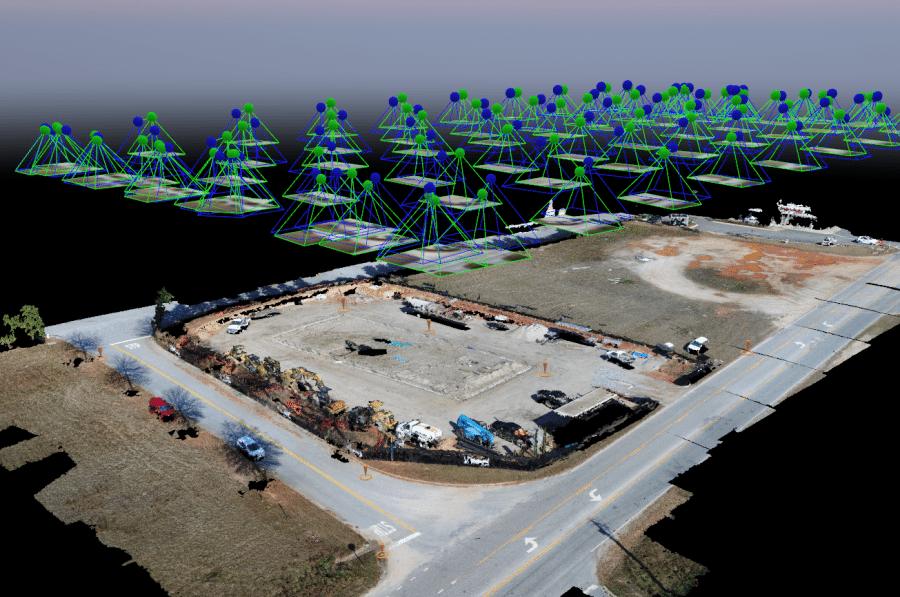
Pix4D Cloud simplifies aerial imaging by providing a centralized, web-based platform for processing and managing drone-captured data. Users can upload images directly to the cloud, where advanced photogrammetry algorithms generate high-resolution 2D maps, 3D models, and orthomosaics.
Why it matters: This eliminates the need for expensive hardware or software installations, allowing teams to access their data anytime, anywhere. With its user-friendly interface, Pix4D Cloud reduces the learning curve, making it accessible to both experienced professionals and newcomers.
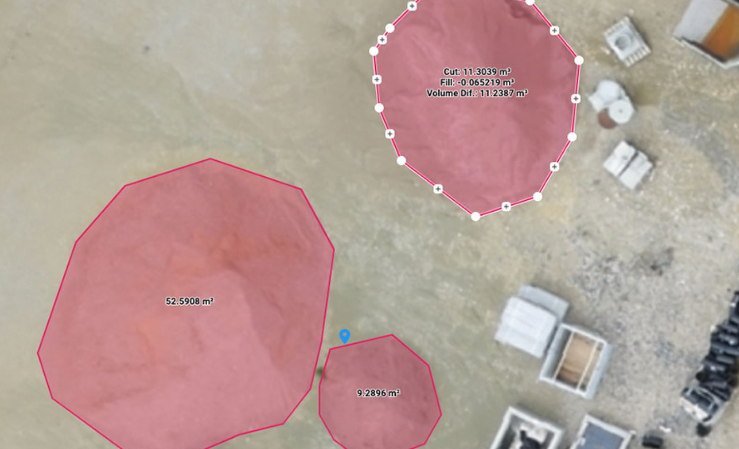
2. Accurate Volume Analysis
One of Pix4D Cloud’s standout features is its robust volume measurement capabilities. Whether calculating stockpile volumes in mining operations or assessing material quantities on construction sites, the platform provides precise and reliable results.
Key benefits:
- Automated volume calculations based on high-resolution 3D models.
- The ability to compare data over time for tracking changes or discrepancies.
- Significant time savings compared to traditional surveying methods.
3. Construction Progress Monitoring
Construction projects demand meticulous planning and execution, often involving multiple stakeholders. Pix4D Cloud enables teams to document and monitor site progress with unparalleled accuracy.
How it helps:
- Regular drone flights can be used to create updated maps and models, providing visual and measurable records of progress.
- Stakeholders can access real-time updates and reports from anywhere, fostering transparency and collaboration.
- Early detection of potential issues helps mitigate delays and cost overruns.
4. Enhanced Inspections
For industries like infrastructure, energy, and agriculture, inspections are critical for safety and performance. Pix4D Cloud optimizes inspection workflows with high-quality imagery and powerful analytical tools.
Advantages include:
- Safe, remote inspections of hard-to-reach or hazardous areas, reducing risk to personnel.
- Detailed, shareable reports with annotations and measurements.
- Rapid turnaround times, enabling faster decision-making and maintenance scheduling.
5. Cost-Effective and Scalable
Pix4D Cloud is designed to grow with your business needs. Its pay-as-you-go model ensures affordability while delivering enterprise-level performance. By eliminating the need for on-site processing infrastructure, the platform reduces operational costs and supports scalability as your projects expand.
6. Collaboration and Accessibility
Sharing data and insights with team members, clients, and stakeholders is seamless on Pix4D Cloud. The platform’s collaboration tools allow multiple users to review and comment on projects, streamlining communication and decision-making.
What this means: Everyone involved in a project has access to the same accurate, up-to-date information, leading to improved alignment and efficiency.
Conclusion
Pix4D Cloud stands out as a transformative tool for professionals across industries. Its ability to deliver precise data, streamline workflows, and enhance collaboration makes it an invaluable asset for aerial imaging, volume analysis, construction progress tracking, and inspections. By adopting Pix4D Cloud, businesses can not only save time and resources but also achieve a higher standard of accuracy and performance in their operations.
Ready to elevate your workflows? Explore the possibilities with Drone Logic and Pix4D and see the difference it can make for your projects.
Drone Logic Aerial Insights