AERIAL MAPPING

Mapping the Future: Unparalleled Precision and Insight with Aerial Drones

Aerial Mapping


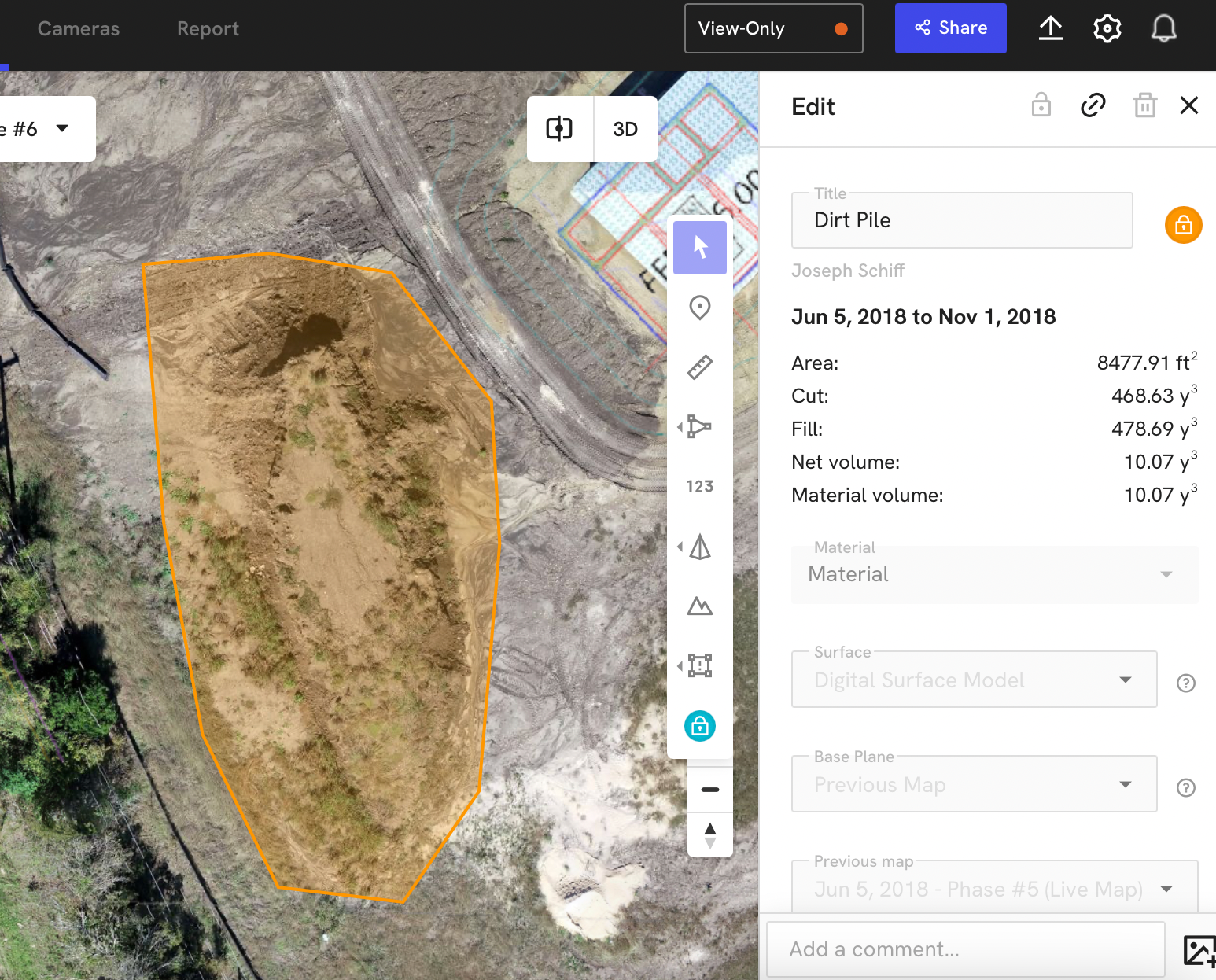
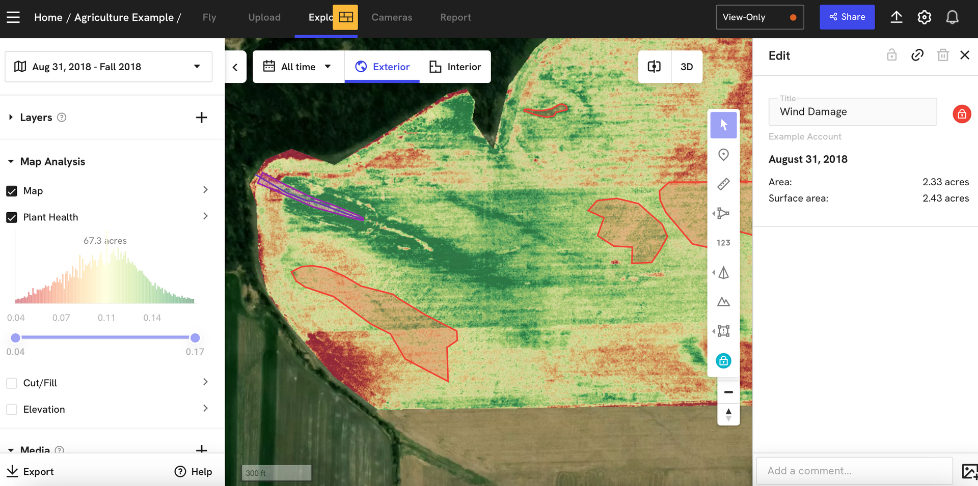
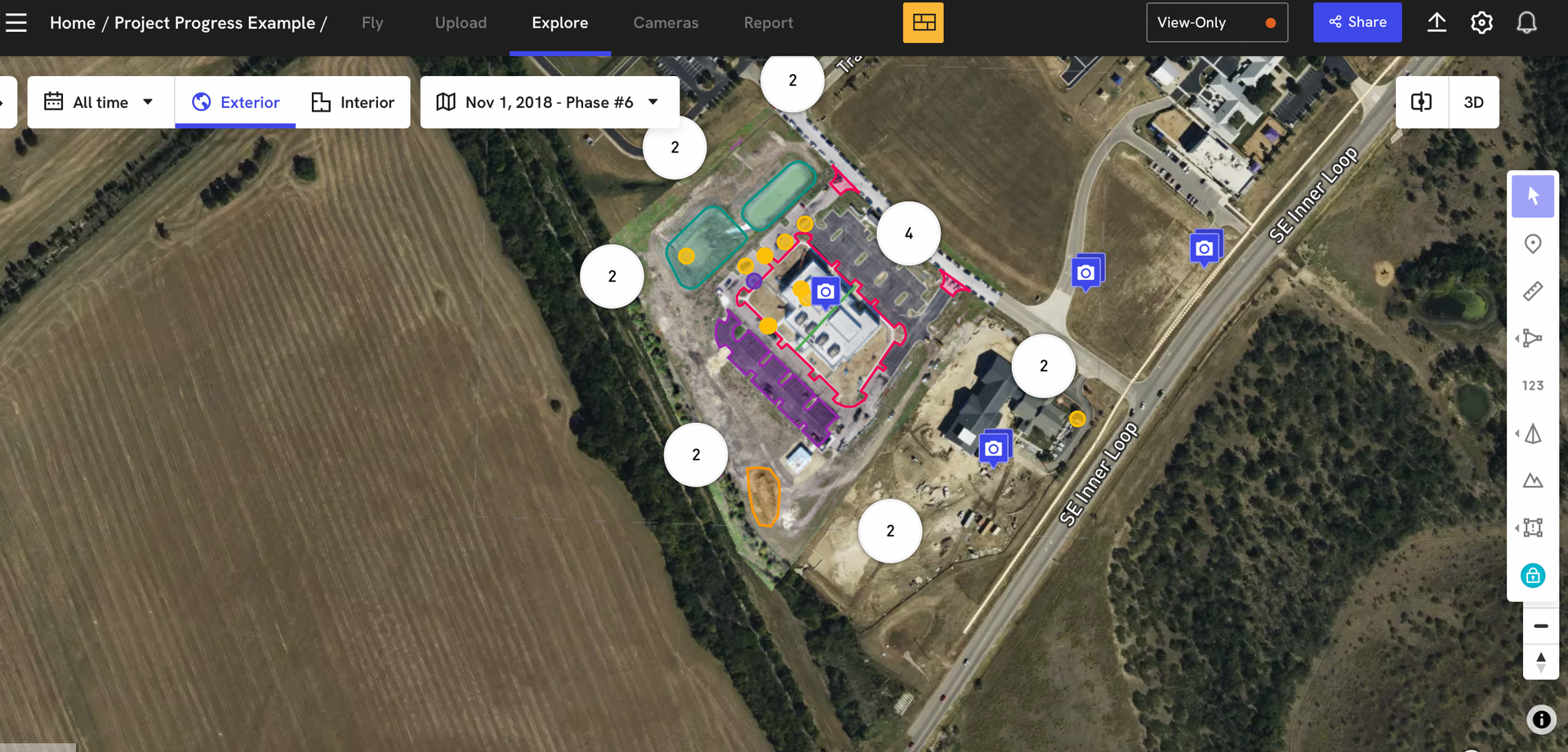
Drone aerial mapping, enhanced by photogrammetry, leverages Real-Time Kinematic (RTK) and Post-Processed Kinematic (PPK) technologies to achieve highly accurate data collection. This level of precision allows for the transformation of imagery from project sites and assets into detailed high-resolution 360-degree panoramas, videos, photos, 2D orthomosaics, and 3D models. The instant RTK and PPK capabilities ensure that the data collected is current and accurate, which is crucial for various applications such as construction, agriculture, and environmental monitoring.


This technology not only provides detailed visual representations but also enables precise measurements to compare the built environment against design plans. Users can overlay design files, tag issues, and create annotations directly on the imagery, facilitating thorough analysis and project management. The ability to measure and report data accurately and share it easily among stakeholders makes drone aerial mapping an invaluable tool for modern site analysis and asset management. This comprehensive approach ensures that any discrepancies can be swiftly identified and addressed, enhancing the overall efficiency and effectiveness of the project.

3D Volumetrics 


Drone imaging technology has revolutionized volumetric analysis, offering a precise and efficient way to gather data. By capturing multiple images of an area, drones can create a detailed photographic map that is geometrically corrected to eliminate distortion, surpassing the accuracy of conventional 2D maps. This advanced mapping capability is particularly valuable in fields such as construction, mining, and agriculture, where precise measurements are crucial for project planning and execution. These detailed maps provide professionals with a comprehensive view of the terrain, enabling them to make informed decisions and identify potential issues early.


The combination of aerial imagery and sophisticated modeling software allows for the creation of 3D or volumetric models, offering an even deeper level of analysis. These models enable professionals to quickly and affordably evaluate topography, monitor the progress of projects, and keep track of environmental changes such as soil erosion. This capability is especially beneficial for ongoing site management, as it allows for the continuous monitoring and assessment of changes over time. By providing accurate and up-to-date information, drone imaging ensures that projects stay on track and within budget, while also safeguarding the environment.

Agriculture


In precision agriculture, aerial drones have become an indispensable tool for boosting crop production. By utilizing thermal or near-infrared imagery, drones can provide detailed assessments of soil health, identifying variations in moisture content and nutrient levels. This information allows farmers to make informed decisions on irrigation and fertilization, optimizing the use of resources and improving overall crop yields. Moreover, drones can pinpoint damage to crops by wind or weed outbreaks, enabling targeted treatment that reduces the need for widespread pesticide application. This precise approach not only enhances crop health but also contributes to sustainable farming practices.


Additionally, drones equipped with advanced imaging technology can evaluate crop consistency, providing valuable insights into plant growth and development. By capturing high-resolution images, drones can detect areas of underperforming crops, allowing farmers to address issues such as disease or pest infestations promptly. This proactive monitoring helps maintain crop health throughout the growing season, ultimately leading to higher quality and more consistent yields. The ability to quickly and efficiently gather this data makes drones an invaluable asset in modern agriculture, transforming traditional farming methods into a more data-driven and precise practice.

High Resolution Aerial Imaging


Aerial drones equipped with high-resolution cameras have revolutionized the way we capture photographs and imagery, providing stunningly detailed visuals from a bird's-eye perspective. These drones use advanced sensors and imaging technology to capture sharp, clear images that can be used in a variety of industries. The high resolution ensures that even the smallest details are visible, making it an ideal tool for tasks such as site inspections, where precision is crucial. Drones can hover and maneuver in hard-to-reach areas, capturing angles and perspectives that would be impossible or too risky for human photographers. This flexibility and capability make aerial drones an indispensable asset for capturing high-quality images.


The applications of aerial imaging extend far beyond photography. In marketing, aerial videography can create captivating promotional content that stands out. Industries such as agriculture, construction, real estate, and environmental monitoring benefit from the detailed aerial imagery drones provide. For instance, thermal imaging can be used to detect heat leaks in buildings or monitor crop health. The ability to quickly deploy drones and capture high-resolution data in real-time enables businesses to make informed decisions swiftly and effectively. This versatile technology not only enhances visibility but also improves efficiency and accuracy across various sectors, proving that almost any industry can benefit from the advantages of aerial imaging.

* Please note the following disclaimer. Documents or data created for clients is for informational purposes only and does not constitute a legal survey or legal map. It has not been prepared or certified in accordance with Pennsylvania surveying standards. If there is a need for a legal survey or legal map, we can partner with Board Certified Land Surveyors to meet your business need.

Share by: